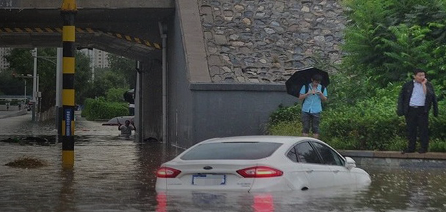
A flooded underpass can bring traffic to a standstill within minutes. During heavy rainfall, water can also accumulate in low-lying streets and drainage networks, creating hazards before emergency teams recognize the problem.
Urban flood monitoring helps cities detect these conditions through real-time water level measurements and connected warning systems. This article explains how waterlogging monitoring technologies work, where to install sensors, and how flood data supports safer roads and faster emergency responses.
Key Technologies Used in Urban Flood Monitoring
Sensors and IoT Devices for Water Level Detection
Sensors and Internet of Things (IoT) devices provide continuous water level measurements in flood-prone urban areas.
Common technologies include:
Ultrasonic Sensors: Measure water levels using reflected sound waves.
Pressure Sensors: Estimate water depth through pressure measurements.
Radar Sensors: Detect changes in water levels without direct contact.
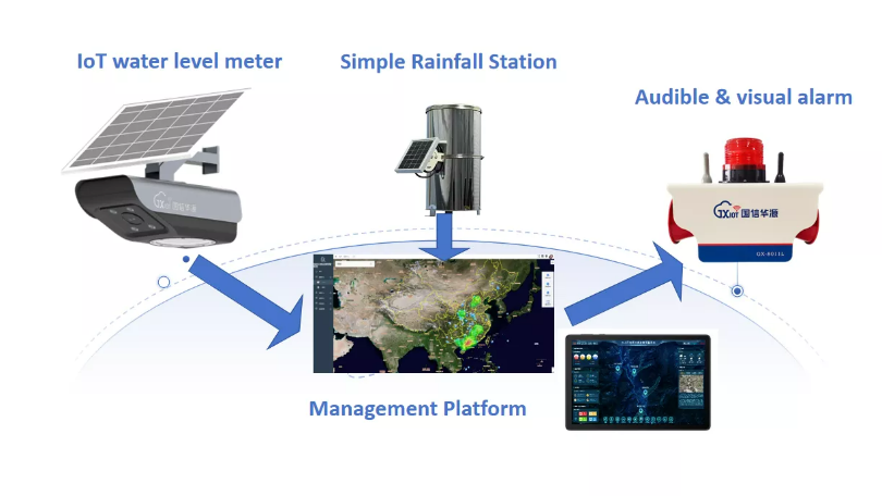
These sensors can be installed near storm drains, rivers, and vulnerable streets. IoT connectivity allows measurements to reach centralized monitoring platforms, supporting early detection of rising water.
Remote Sensing and Satellite Imagery Applications
Remote sensing technologies collect environmental information across large urban areas.
Satellite imagery helps monitor rainfall distribution, soil moisture, and flood extent. Synthetic aperture radar (SAR) satellites can also observe surface conditions through cloud cover and during darkness.
For example, the European Space Agency's Sentinel satellites provide imagery that can support urban flood assessment.
Combining satellite observations with ground sensor measurements improves understanding of flood conditions across a city.
Role of Geographic Information Systems (GIS) in Flood Monitoring
Geographic Information Systems (GIS) integrate flood measurements with spatial information, including terrain, infrastructure, and drainage networks.
GIS platforms support several functions:
Flood Risk Mapping: Identify vulnerable neighborhoods and infrastructure.
Scenario Analysis: Simulate possible flooding conditions.
Real-Time Visualization: Display sensor measurements and affected locations.
Emergency Planning: Support resource allocation and response decisions.
Interactive maps also help authorities communicate flood warnings and road conditions to residents.
Use of Drones and Automated Cameras for Real-Time Data Collection
Drones and automated cameras provide visual information that complements fixed monitoring equipment.
Drones can capture high-resolution images of flooded streets and inaccessible areas. Automated cameras installed near rivers, drainage channels, or roads allow continuous observation of changing conditions.
Some drones also carry thermal imaging equipment for additional environmental assessment.
Together, these technologies improve situational awareness and support faster identification of flood-affected locations.
Tip: Combine IoT sensors, GIS platforms, and visual monitoring technologies to improve coverage and response efficiency.

Components of an Effective Waterlogging Monitoring System
Water Level Sensors and Placement Strategies
Water level sensors are essential for detecting urban waterlogging.
Ultrasonic, pressure, and radar sensors measure changes in water depth. Their effectiveness depends on selecting suitable installation locations.
Priority monitoring areas often include:
Low-lying streets and intersections.
Road underpasses.
Storm drains and drainage channels.
Riverbanks near developed areas.
Installing sensors at multiple locations helps identify differences in water accumulation and detect flooding before conditions worsen.
Data Transmission and Communication Technologies
Monitoring stations require dependable communication networks to transmit water level measurements.
Different technologies offer advantages depending on coverage and infrastructure.
Communication Technology | Main Characteristics | Typical Application |
LoRaWAN | Long-range, low-power communication | Distributed urban sensor networks |
Cellular Networks (4G/5G) | Wireless data transmission through mobile infrastructure | Connected monitoring stations |
Wi-Fi | Local wireless network connectivity | Locations with available network infrastructure |
Backup Communication Links | Alternative paths when primary connections fail | Improving system reliability during storms |
Secure transmission and backup connectivity help protect monitoring data and reduce communication interruptions.
Centralized Data Processing and Monitoring Platforms
Centralized platforms collect sensor measurements and combine them with weather forecasts, satellite observations, and other monitoring information.
Cloud-based systems support data storage and remote access. Advanced analytics can identify flooding patterns and estimate waterlogging severity.
Monitoring dashboards present real-time conditions to city officials and emergency responders, helping them prioritize affected locations and coordinate resources.
Alert Systems and Public Notification Mechanisms
Waterlogging monitoring systems can issue warnings when water levels exceed predefined thresholds.
Alerts may be delivered through SMS, mobile applications, sirens, digital signs, and social media.
For example, a city monitoring platform may notify drivers about flooded roads and temporary closures through a mobile application.
Clear, timely communication helps residents avoid dangerous areas and supports emergency preparedness.
Methods for Road Flood Monitoring and Assessment
Detecting Waterlogging on Roadways Through Sensor Networks
Road flood monitoring systems measure water accumulation along vulnerable road sections.
Ultrasonic, infrared, and pressure sensors may be installed near drainage points, above road surfaces, or at other suitable locations.
When water levels exceed established thresholds, monitoring equipment sends alerts to traffic management centers.
This allows authorities to identify potentially unsafe roads and respond before conditions become more dangerous.
Integration of Traffic Management Systems with Flood Data
Integrating flood measurements with traffic management platforms supports safer transportation during heavy rainfall.
Real-time information can help traffic authorities:
Adjust traffic signals when necessary.
Redirect vehicles away from flooded routes.
Display warnings on electronic road signs.
Coordinate road closures and emergency access.
These measures help reduce congestion and limit exposure to dangerous road conditions.
Real-Time Mapping of Flood-Affected Roads
Real-time flood maps provide a visual overview of road conditions across urban areas.
GIS platforms combine information from sensors, drones, and cameras to display flooded locations, road closures, and alternative routes.
Emergency responders can use these maps to plan safer access, while residents can check available routes through public information platforms.
Updated mapping also helps traffic authorities allocate resources more efficiently.
Predictive Analytics for Anticipating Road Waterlogging Events
Predictive systems analyze historical flood data, weather forecasts, rainfall intensity, and drainage conditions.
Machine learning models may identify road sections more likely to experience waterlogging under specific weather conditions.
These predictions support preventive actions such as preparing drainage pumps, issuing early warnings, or planning temporary road closures.

Benefits of Real-Time Urban Flood and Road Waterlogging Monitoring
Improved Emergency Response and Disaster Management
Real-time monitoring provides emergency teams with updated information about water levels and flood locations.
This helps authorities identify high-risk areas, plan evacuation measures, and deploy resources where they are most needed.
Monitoring data also supports rescue coordination by helping responders avoid flooded or unsafe routes.
Reducing Economic Losses and Infrastructure Damage
Urban flooding can damage roads, buildings, public utilities, and commercial facilities.
Early detection allows authorities to take preventive measures, including activating drainage pumps and closing vulnerable roads.
Businesses can also use warnings to protect equipment and prepare for possible interruptions.
Over time, monitoring records help cities identify infrastructure weaknesses and prioritize maintenance investments.
Enhancing Public Safety and Awareness
Timely flood information helps residents make safer decisions during severe weather.
Mobile notifications, SMS messages, and digital road signs can communicate dangerous conditions and road closures.
Public access to updated flood information also improves awareness of local risks and encourages cooperation with emergency authorities.
Supporting Urban Planning and Flood Mitigation Strategies
Long-term flood monitoring data helps urban planners understand recurring flooding patterns.
Its applications include:
Identifying areas that require drainage improvements.
Evaluating potential flood protection measures.
Supporting infrastructure planning.
Analyzing historical flood trends.
Prioritizing investments in vulnerable locations.
Combining historical records with current measurements helps cities develop more effective flood mitigation strategies.
Challenges and Solutions in Implementing Flood and Waterlogging Monitoring Systems
Technical Challenges in Sensor Deployment and Data Accuracy
Urban sensors operate in environments exposed to debris, harsh weather, and potential equipment damage.
Poor placement can cause inaccurate readings or leave important locations unmonitored. Sensors installed in drainage systems may also become obstructed.
Regular calibration, cleaning, and inspection help maintain measurement accuracy.
Using different sensor technologies to verify measurements can further improve monitoring reliability.
Data Integration from Diverse Sources
Urban flood monitoring platforms combine information from sensors, satellites, drones, weather stations, and traffic systems.
These sources differ in measurement accuracy, update frequency, and data format.
The following table summarizes common integration challenges.
Data Source | Main Challenge | Integration Approach |
Ground Sensors | Different measurement formats and accuracy | Standardized data processing |
Satellite Imagery | Less frequent updates than continuous sensors | Combine with real-time ground measurements |
Drones and Cameras | Large volumes of visual information | Centralized analysis platforms |
Weather Stations | Different reporting intervals | Data synchronization |
Traffic Systems | Compatibility between platforms | APIs and shared communication protocols |
Cloud-based platforms and advanced analytics help combine these datasets into a more consistent monitoring environment.
Cost Considerations and Funding for Monitoring Infrastructure
Building a citywide monitoring network requires investment in sensors, communication equipment, software, and maintenance.
Costs increase as monitoring coverage expands across roads, drainage networks, and other vulnerable areas.
Cities can manage expenses by prioritizing high-risk locations and considering lower-cost IoT devices or open-source software.
Government grants, public-private partnerships, and international assistance may also support implementation.
Ensuring System Scalability and Maintenance
Flood monitoring infrastructure must adapt as urban areas expand and monitoring requirements change.
Modular system designs allow new sensors and technologies to be integrated without replacing the entire platform.
Regular maintenance remains essential. Sensors require calibration, communication networks need monitoring, and software must be updated.
Automated diagnostics and staff training can help identify equipment problems early and reduce downtime.

Case Studies of Urban Flood Monitoring and Road Waterlogging Systems
Successful Implementations in Major Cities
Major cities have adopted different technologies to monitor flooding and improve emergency response.
Singapore: Urban flood management uses monitoring sensors and digital systems to track drainage conditions and flood-prone locations. This information supports warnings and water management during heavy rainfall.
Houston, United States: Flood monitoring approaches use environmental measurements, mapping technologies, and remote observations to assess developing flood conditions.
These examples illustrate how integrating different data sources can improve awareness of urban flooding and support emergency decisions.
Lessons Learned from Flood Monitoring Projects
Experience from urban flood monitoring highlights several important factors.
Sensor placement strongly influences data accuracy and monitoring coverage. Regular maintenance also helps prevent equipment failures and incorrect measurements.
Reliable data integration is essential when combining information from different technologies.
Cooperation between city agencies, technology providers, and local communities further supports effective monitoring and public trust.
Innovations Driving Future Urban Flood Monitoring
New technologies are expanding the capabilities of urban flood monitoring systems.
Artificial Intelligence and Machine Learning: Analyze complex data patterns to support flood forecasting.
Edge Computing: Processes information near sensors, potentially reducing delays in alert generation.
Advanced Drone Monitoring: Uses image analysis to assess flooded areas and infrastructure conditions.
Blockchain Technology: Offers potential methods for secure and transparent information sharing.
Smart City Integration: Connects flood monitoring with other urban management systems to support coordinated operations.
These developments may improve monitoring efficiency, data accessibility, and emergency preparedness.
Community Involvement and Stakeholder Collaboration
Community participation helps monitoring systems respond to actual local needs.
Residents can report flooded streets, blocked drains, or infrastructure damage through mobile applications.
Public awareness programs explain flood risks and encourage appropriate safety measures.
Cooperation between local governments, emergency services, technology providers, and residents helps strengthen communication and improve response coordination.
Tip: Involve communities and relevant city agencies early to improve monitoring coverage, public awareness, and long-term system effectiveness.
Conclusion
Urban flooding becomes especially dangerous when rising water goes undetected on busy roads, underpasses, and low-lying streets. Real-time monitoring gives city authorities a clearer picture of these risks, helping them identify hazardous locations before conditions worsen.
An effective waterlogging monitoring system combines strategically placed water level sensors with reliable communication networks and centralized data analysis. GIS mapping, automated cameras, and traffic management integration further improve its usefulness by turning measurements into practical decisions, such as closing flooded roads, redirecting vehicles, or activating drainage equipment.
Long-term reliability also depends on proper sensor placement, routine maintenance, and the ability to integrate information from different monitoring technologies. Cities should prioritize vulnerable locations while designing systems that can expand as infrastructure and monitoring requirements change.
For urban drainage networks and flood-prone transportation infrastructure, BGT Hydromet provides hydrometeorological monitoring equipment and real-time flood monitoring solutions. Combining dependable field measurements with coordinated emergency procedures helps cities improve road safety, manage waterlogging risks, and strengthen flood preparedness.
FAQ
Q: What is urban flood monitoring and how does a waterlogging monitoring system work?
A: Urban flood monitoring uses sensors, IoT devices, and GIS platforms to track water levels. A waterlogging monitoring system detects water accumulation in vulnerable locations and supports real-time alerts.
Q: How does road flood monitoring improve traffic safety during floods?
A: Road flood monitoring detects water accumulation on roadways and shares information with traffic management systems. This supports warnings, road closures, and safer route planning.
Q: Why is real-time urban flood monitoring important for emergency response?
A: Real-time monitoring provides updated information about flood locations and severity, helping emergency teams coordinate resources and respond more efficiently.
Q: What challenges exist in deploying a waterlogging monitoring system?
A: Common challenges include sensor durability, data accuracy, communication reliability, system integration, and implementation costs. Regular maintenance and suitable monitoring platforms help address these issues.
Q: How much does it cost to implement a road flood monitoring system?
A: Costs vary according to sensor types, monitoring coverage, communication infrastructure, and software requirements. Prioritizing high-risk locations and using suitable IoT technologies can help control expenses.