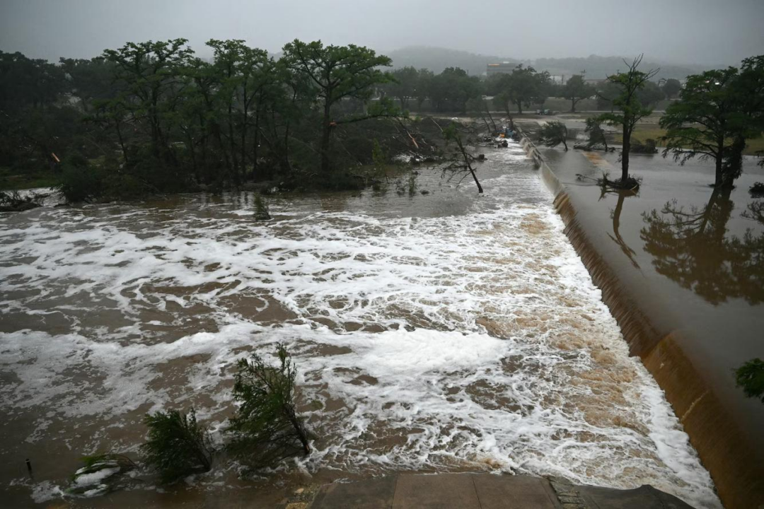
On July 4, 2025, catastrophic Texas flash flooding struck multiple regions of Texas overnight, breaching levees and destroying roads/bridges. As of July 7, confirmed deaths exceed 104, with 24 still missing and 850 rescued. Estimated economic losses: $18–22 billion. The President has declared Kerr County a "Major Disaster Zone." Preliminary reports reveal critical flaws in Texas’ flood defense systems—and urgent lessons for the future.
Five Fatal Flaws in Texas’ Warning System Exposed
Forecast Failure The National Weather Service (NWS) drastically underestimated rainfall (actual: 406mm in Mason County) and missed the flash flood Texas camp zone entirely. Key data about stalled tropical storm remnants went undetected.
Delayed Warnings A flash flood warning for the Guadalupe River was issued at 1:14 AM but failed to cover critical areas. Deadly floods hit at 3 AM—phone alerts arrived at 4 AM, and many never received them. The gap between warning and disaster proved fatal.
Missing Infrastructure Kerr County’s planned flood sirens (shelved for 9 years) left riverside residents defenseless in the dark. Local Texas flooding warning systems were virtually nonexistent.
Emergency Breakdown The "Texas flooding flash flood camp" had no nighttime evacuation plan or designated high-ground shelters. The county’s emergency director admitted: "No warning system... we never expected this."
Expertise Gap Trump-era cuts eliminated hundreds of NOAA and NWS positions. Texas’ hydrology forecasting teams are understaffed, leaving offices unable to operate 24/7—a flaw also seen in New Mexico flooding responses.
Core Elements of an Ideal Flood Warning System
1. Smart Forecasting "Radar Net"
Multi-source data fusion: Satellites, radar, ground stations, and IoT sensors form an "air-space-ground" monitoring grid. Critical: Add sensors in hilly terrain (blind spots that worsened New Mexico flooding).
AI flood models: Machine learning analyzes historical data + real-time hydrology to simulate water flow and pinpoint high-risk zones (e.g., flash flood Texas camp sites, valley towns).
2. Second-Response Warning Chain
Omnichannel alerts: Cell broadcasts (bypassing dead zones), community sirens, smart alarms, and GPS-triggered flash flood warnings ensure 100% reach—even in remote areas like the doomed camp.
Auto-triggered evacuations: Threshold-based protocols (e.g., 50mm/hour rainfall) activate evacuation instructions automatically, eliminating human delays. Night mode must override device silence.
3. AI-Powered Emergency Platform
Digital twin simulations: Virtual models of rivers/communities rehearsal flood scenarios to optimize evacuation routes and shelter capacity.
Live risk maps: Public access to real-time water levels/road closures. Solves the "where to flee" crisis—a gap seen in Texas flooding flash flood camp tragedies.
4. Protection for Vulnerable Groups
Campsite mandates: High-risk zones (e.g., flash flood Texas camp areas) require water sensors, elevated shelters, and nighttime drills.
Tourist alerts: Booking apps/navigation tools must auto-push destination-specific Texas flash flooding risks and survival steps.
The Bottom Line: Climate Crisis Demands Systems That Leave No One Behind
Fragmented warning systems are obsolete. The Texas flooding disaster proves: Every second counts, and every mile matters. From New Mexico flooding blind spots to Kerr County’s uninstalled sirens, the "last mile" of warning delivery remains a lethal weak spot.
Warning systems only save lives when they trigger action—before the water rises.