The Naviboat 8 is a versatile and intelligent unmanned surface vessel (USV) designed to meet over 95% of industry applications in water environments. Built with high-strength polymer carbon fiber and Kevlar using vacuum infusion technology, it offers a lightweight yet robust structure (1280×580×430mm, 15kg without battery, 50kg payload). Equipped with GNSS+IMU navigation, millimeter-wave obstacle avoidance, 360° panoramic video, and autonomous return functions, Naviboat 8 delivers reliable and safe operations across complex water conditions.
Its modular design with a 30cm central moon pool provides exceptional flexibility for mounting a wide range of instruments, enabling multi-task operations such as in-situ nutrient monitoring, hydrographic surveying, hydrological flow measurement, sediment profiling, and multi-parameter water sampling.
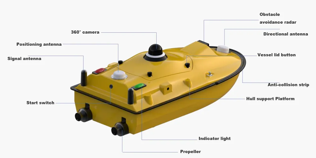
![Naviboat 8 Pollution Monitoring USV]()
Key Technical Features
Intelligent Navigation & Control: Supports autonomous route planning and stable operation under wind and wave conditions.
Track Recording & Return-to-Path: Automatically records navigation routes, enabling path-following return and reverse tracking.
Obstacle Avoidance: Utilizes radar and cameras for obstacle detection and autonomous avoidance.
Station-Keeping Function: Maintains position in flowing water by adjusting propulsion, ideal for fixed-point operations.
AI Target Recognition with GIS Mapping: Onboard AI module identifies specific targets and synchronizes georeferenced recognition data with the GIS management platform in real time.
Ergonomic Remote Controller: Handheld design with protective casing, dual-fan cooling, and anti-drop materials for stable field operation.
Ruggedized Interfaces: All external ports are dust-protected to ensure stable performance in harsh environments.