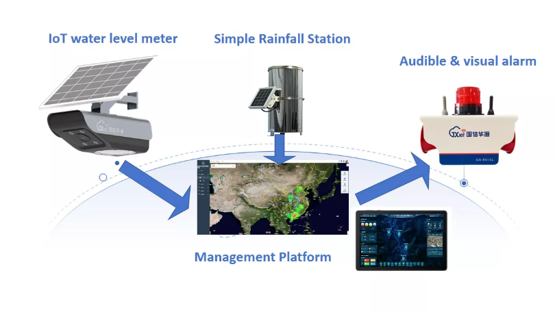
In mountainous regions, steep slopes and narrow valleys can turn intense rainfall into dangerous flash floods within minutes. Limited road access and unstable communication networks make emergency response even more difficult.
Building an effective flash flood monitoring and early warning system requires more than installing sensors. It involves strategic monitoring locations, reliable data transmission, accurate forecasting, and warning procedures adapted to mountainous terrain.
Understanding Flash Floods in Mountainous Areas
Causes and Characteristics of Flash Floods in Mountainous Terrain
Flash floods in mountainous regions often develop after intense rainfall. Steep slopes accelerate runoff, while narrow valleys concentrate water into fast-moving streams.
Mountain soils may be thin or rocky, limiting water absorption. As water moves downhill, it can carry rocks, mud, and debris, increasing the potential for damage.
These conditions allow water levels to rise rapidly, leaving communities with limited warning time.
Impact of Topography and Weather Patterns on Flash Flood Occurrence
Mountain terrain and weather conditions strongly influence flash flood risks.
Several factors contribute to sudden flooding:
Steep Slopes: Accelerate surface runoff into rivers and streams.
Narrow Valleys: Concentrate water flow and increase flood intensity.
Heavy Thunderstorms: Produce intense rainfall over short periods.
Rapid Snowmelt: Adds water to rivers and surrounding drainage systems.
Saturated Soil: Reduces water absorption and increases runoff.
Understanding these conditions helps identify areas where flash flood monitoring is most important.
Common Challenges in Predicting Flash Floods in Mountainous Regions
Predicting mountain flash floods is difficult because rainfall and terrain conditions vary significantly over short distances.
Remote locations complicate sensor installation, while mountains can block communication signals. Sudden weather changes also make forecasting more challenging.
Accurate predictions require detailed environmental data, reliable transmission, and forecasting models suited to local terrain.

Essential Flash Flood Sensors for Effective Monitoring
Types of Flash Flood Sensors: Rain Gauges, Water Level Sensors, and Flow Meters
Flash flood monitoring systems use different sensors to measure changing environmental conditions.
Sensor Type | Main Function | Monitoring Value |
Rain Gauges | Measure rainfall intensity and accumulation | Identify heavy rainfall that may trigger flooding |
Water Level Sensors | Track water levels in rivers and streams | Detect sudden rises in water height |
Flow Meters | Measure water velocity and flow | Assess flood intensity and downstream risks |
Combining these measurements provides a more complete understanding of developing flood conditions.
Criteria for Selecting Sensors Suitable for Mountainous Environments
Mountain monitoring equipment must operate reliably despite difficult weather and limited infrastructure.
Important selection factors include:
Durability: Resistance to harsh weather, temperature changes, and debris.
Accuracy: Ability to detect rapid changes in rainfall and water levels.
Power Efficiency: Low-energy operation or solar power for remote locations.
Communication: Reliable data transmission across difficult terrain.
Maintenance: Accessible designs that simplify inspection and calibration.
Choosing sensors suited to local conditions helps improve monitoring reliability.
Installation Best Practices for Reliable Sensor Data
Proper sensor placement is essential for accurate measurements.
Rain gauges should be installed in open areas away from major obstructions. Water level sensors require stable mounting locations near rivers or channels.
Equipment must be secured against floodwater, debris, and environmental damage. Protective barriers may also help reduce interference from wildlife.
Initial calibration and additional sensors at critical locations improve system reliability.
Maintenance and Calibration of Flash Flood Sensors
Regular maintenance helps prevent sensor failures and inaccurate readings.
Typical maintenance tasks include inspecting equipment for damage, cleaning debris, checking calibration, and updating firmware.
Battery-powered or solar-powered stations also require periodic power system checks.
Consistent maintenance ensures monitoring equipment remains operational during severe weather.
Tip: Prioritize durable, low-power sensors with reliable wireless communication for remote mountain monitoring stations.
Designing a Flash Flood Warning System Tailored for Mountainous Areas
System Architecture Overview: Sensor Networks, Data Transmission, and Processing
A mountain flash flood warning system combines environmental sensors, communication networks, and centralized data processing.
Sensors collect rainfall, water level, and flow measurements across selected monitoring locations. Radio, cellular, or satellite networks transmit these measurements to processing systems.
Servers or cloud platforms then analyze incoming information to identify potential flood risks.
The architecture should support additional monitoring stations and alternative communication paths if primary connections fail.
Integration of Real-Time Data from Flash Flood Sensors
Continuous data integration allows monitoring systems to identify dangerous changes quickly.
Rain gauges, water level sensors, and flow meters transmit measurements to a central platform. The system checks data quality and removes unreliable readings caused by equipment faults or environmental interference.
Combining multiple measurements helps identify rapid water level increases and intense rainfall events.
This information supports timely decisions by emergency management teams.
Use of Predictive Models and Algorithms for Early Warnings
Forecasting models analyze environmental conditions to estimate flash flood risks.
These models consider rainfall intensity, soil saturation, terrain slope, and river flow. Hydrological and hydraulic models simulate water movement and potential flood impacts.
Machine learning algorithms may also analyze historical events and incoming measurements to improve predictions.
Model outputs can be compared with warning thresholds to support timely alerts.
Communication Channels for Timely Alerts to Local Communities
A warning system must deliver clear information to residents, authorities, and emergency responders.
Different communication channels serve different purposes:
SMS and Mobile Apps: Send direct warnings to residents and officials.
Sirens and Loudspeakers: Provide immediate alerts in vulnerable communities.
Radio and Television: Reach broader audiences, including travelers.
Websites and Social Media: Share updates and safety instructions.
Combining multiple channels helps maintain warning coverage when communication networks are disrupted.

Data Collection and Analysis for Flash Flood Monitoring
Techniques for Collecting Accurate Hydrological and Meteorological Data
Reliable flash flood monitoring depends on accurate measurements from strategically located sensors.
Automated rain gauges record precipitation at short intervals, helping detect sudden heavy rainfall. Water level sensors track changes in rivers and streams, while flow meters measure water velocity and discharge.
Nearby weather stations provide additional information about temperature, humidity, and wind conditions.
In mountainous regions, a dense monitoring network helps capture localized rainfall events. Drones and mobile monitoring equipment can supplement fixed stations in difficult-to-access locations.
Data Management and Storage Considerations
Flood monitoring systems continuously generate large amounts of environmental data. Efficient storage and management are essential for reliable analysis.
Cloud-based platforms allow monitoring stations to upload measurements for centralized processing and remote access. Each record should include a timestamp and geographic location.
Data quality control helps identify inaccurate or missing measurements, while backup storage reduces the risk of data loss.
Security measures are also important when sharing monitoring information with emergency management agencies and other organizations.
Analyzing Sensor Data to Detect Flash Flood Indicators
Flash flood detection requires analyzing multiple environmental indicators rather than relying on a single measurement.
The following table shows how different data types contribute to flood risk assessment.
Monitoring Data | Key Indicators | Role in Flood Warning |
Rainfall Data | Sudden increases in rainfall intensity | Identifies heavy precipitation that may trigger flash floods |
Water Level Data | Rapid rises in rivers and streams | Detects increasing flood risks |
River Flow Data | Increased water velocity and discharge | Helps assess flood intensity and downstream impacts |
Historical Flood Records | Previous rainfall and flood patterns | Supports warning threshold development |
Weather Data | Temperature, humidity, and changing conditions | Provides additional information for flood forecasting |
Monitoring platforms compare incoming measurements with established thresholds to identify potential flood conditions.
Machine learning algorithms can also analyze historical patterns and support flood prediction. Visualization dashboards display measurements through maps, graphs, and alerts, allowing emergency managers to assess conditions quickly.
Leveraging GIS and Remote Sensing in Flash Flood Monitoring
Geographic Information Systems (GIS) combine monitoring data with terrain maps, land use information, and hydrological features.
This spatial analysis helps identify flood-prone areas and potential water flow paths.
Satellite imagery and drones provide additional observations of vegetation, soil moisture, and surface water conditions. When combined with ground sensor measurements, these technologies support more detailed flood risk assessments.
GIS-based models can also simulate potential flood scenarios, improving emergency planning and response.

Implementing and Maintaining the Flash Flood Warning System
Steps for Deploying the Monitoring and Warning System in Mountainous Areas
Building a flash flood warning system requires careful planning, installation, and testing.
The deployment process generally follows these stages:
Site Assessment: Identify flood-prone areas, suitable sensor locations, and installation challenges.
Sensor Installation: Install rain gauges, water level sensors, and flow meters with appropriate protection.
Communication Setup: Establish radio, cellular, or satellite connections for data transmission.
System Integration: Connect sensors to processing platforms and verify incoming measurements.
Testing and Calibration: Check sensor accuracy, communication reliability, and alert functions.
Operational Planning: Establish emergency procedures and maintenance schedules.
Each stage helps ensure the monitoring system operates reliably under local conditions.
Training Local Authorities and Communities on System Use
Training helps emergency personnel and residents understand how to respond to flood warnings.
Local authorities should learn how to interpret monitoring dashboards, recognize warning levels, and activate emergency procedures.
Community awareness programs can explain alert messages, evacuation routes, and appropriate safety actions.
Regular training sessions and drills help maintain preparedness and improve coordination during emergencies.
Regular System Testing and Performance Evaluation
Routine testing verifies whether the warning system can operate effectively during flood events.
Testing should assess sensor performance, data transmission, forecasting outputs, and alert delivery.
Important evaluation factors include measurement accuracy, false alarm rates, and warning timeliness.
Feedback from emergency services and local communities can help identify weaknesses. Software updates and corrective actions support continuous improvement.
Addressing Technical Challenges and Ensuring System Resilience
Mountainous environments present several operational challenges, including signal blockage, power interruptions, and equipment damage.
Possible solutions include backup sensors, alternative communication routes, and reliable power supplies.
Solar panels and long-life batteries can support remote monitoring stations, while weatherproof enclosures and secure mounts protect equipment from harsh conditions.
Remote monitoring tools also help detect equipment malfunctions before they affect system performance.
Tip: Involve local authorities and communities throughout installation, training, and maintenance to improve system reliability and emergency preparedness.
Case Studies and Success Stories of Flash Flood Monitoring Systems
Examples of Effective Flash Flood Warning Systems in Mountainous Regions
Mountainous regions have adopted different approaches to flood monitoring based on local conditions and available resources.
Swiss Alps: Monitoring approaches use networks of rainfall and water level sensors, supported by centralized data platforms. Mobile alerts and sirens help communicate flood risks to local communities.
Rocky Mountains, United States: Flood monitoring approaches combine environmental sensors, hydrological modeling, satellite observations, and GIS data to identify vulnerable locations and support warnings.
Mountainous Regions of Nepal: Community-based monitoring programs use relatively low-cost sensors and mobile communication networks. Local volunteers contribute to equipment maintenance and warning procedures.
These regional examples illustrate different monitoring approaches. Their effectiveness depends on sensor coverage, forecasting capability, and community response.
Lessons Learned from Past Implementations
Experience from mountain flood monitoring projects highlights several important lessons.
Early community involvement helps build trust and encourages residents to respond to warnings. Backup sensors and communication channels reduce the impact of equipment failures.
Regular maintenance remains essential for reliable measurements, while forecasting models must reflect local terrain and rainfall patterns.
Training and emergency drills also help authorities and residents understand warning messages and take appropriate action.
Innovations in Flash Flood Sensors and Monitoring Technology
New monitoring technologies are improving data collection and system flexibility.
Smart sensors can combine multiple measurements, while low-power wireless communication and solar energy support remote installations.
AI-based analysis helps identify flood patterns and refine forecasting models. Drones equipped with imaging systems provide additional information about developing flood conditions.
Cloud platforms support real-time visualization and remote data access. Open data standards can also improve compatibility between monitoring equipment.
Research into environmentally friendly sensor materials may further reduce the environmental impact of monitoring installations.
Conclusion
The success of a mountain flash flood warning system depends on how well its components work together under difficult environmental conditions. Rain gauges, water level sensors, and flow meters provide essential measurements, but their placement must account for steep terrain, localized rainfall, and rapidly changing river conditions.
Reliable communication is equally important. Backup power supplies, alternative transmission routes, and regular equipment maintenance help prevent interruptions when severe weather affects remote monitoring stations. Combining these measures with locally adapted forecasting models, GIS analysis, and clear emergency procedures creates a stronger foundation for flood preparedness.
Technology alone, however, cannot guarantee an effective response. Local authorities and communities must understand warning signals, practice emergency procedures, and know how to act when flood risks increase.
For projects requiring dependable monitoring in challenging environments, BGT Hydromet provides hydrometeorological monitoring equipment and flash flood early warning solutions. Selecting suitable sensors and integrating them into a coordinated warning network can help mountain communities respond earlier and reduce potential flood damage.
FAQ
Q: What is a flash flood monitoring system and why is it important in mountainous areas?
A: A flash flood monitoring system uses sensors to detect rapid changes in rainfall, water levels, and river flow. It provides early warnings in mountainous areas where steep terrain can cause sudden flooding.
Q: How do flash flood sensors work in mountainous regions?
A: Flash flood sensors measure rainfall, water levels, and flow rates. They transmit data to processing systems that analyze flood risks and support timely warnings.
Q: What are the benefits of installing a flash flood warning system in mountain areas?
A: These systems support early flood detection, improve emergency preparedness, and help reduce potential casualties and property damage.
Q: How much does it cost to build a flash flood monitoring and warning system?
A: Costs depend on sensor types, monitoring network size, communication infrastructure, and system complexity. Durable equipment and reliable data transmission are important investment considerations.
Q: What challenges exist in using flash flood sensors in mountainous terrain?
A: Common challenges include difficult sensor placement, communication signal blockage, power limitations, and rapidly changing weather. Rugged equipment and backup communication systems help improve monitoring reliability.