Communities that use real-time monitoring get more early warnings and better predictions. People can leave safely and on time. With good data, you can plan flood discharge and lower losses, even when it rains hard or at night.
Key Takeaways
Real-time hydrological monitoring lets people spot flood risks early. This helps people leave in time and stay safer.
Using advanced sensors like Precipitation and Level Sensors gives correct data. This data helps plan for floods and lowers damage.
Early warning systems save lives. They give people more time to get ready for floods. This can make disasters less harmful.
Real-time data helps people respond faster in emergencies. This lets emergency teams move quickly to keep people and homes safe.
Hydrological monitoring can also make water cleaner. It helps keep rivers and lakes free from pollution. This is good for people and nature.
Hydrological Monitoring Overview
What Is Hydrological Monitoring
Hydrological monitoring helps you learn how water moves and changes. This system lets you watch rainfall, river levels, water flow, and water quality. You collect information from places like rivers, lakes, and rainfall stations.
You use different tools for this work:
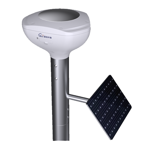
Precipitation Sensors tell you how much rain falls.
Level Sensors show how high the water is in rivers or lakes.
Velocity & Flow Sensors tell you how fast water moves and how much water goes through a channel.
Water Quality Sensors check if the water is clean by measuring things like pH and dissolved oxygen.
A good hydrological monitoring system has some key parts:
When you use all these sensors together, you can see what is happening with your water resources.
You need to follow steps to make sure your data is good:
Set clear goals for data quality and safety.
Use standard steps so your data stays the same.
Check your data often and review it to keep it correct.
Why Real-Time Data Matters
Real-time data monitoring gives you information right away. This helps you see problems like rising water or heavy rain fast. You can warn people and protect your community quickly.
Let’s look at real-time data and periodic data collection:
Model Type | MAE (t+1hr) | RMSE (t+1hr) | Performance Over Time |
Mixed Dataset (Real-time + Simulated) | Minimal | Minimal | Consistent accuracy |
Periodic Data Collection | Higher | Higher | Deteriorating accuracy |
With real-time data, your flood predictions stay correct and on time. You can make better choices and act faster. This helps lower flood damage and keeps people safe.
Hydrological monitoring with real-time data helps you manage water, plan for emergencies, and protect nature. When you use advanced sensors and smart systems, you get the information you need, right when you need it.
Floods and Risk Challenges
Causes of Floods
Floods can start for many reasons. Heavy rain can make rivers and streams fill up fast. Snow melting quickly in spring can also raise water levels. People can make floods worse too. When cities and roads are built, water cannot go into the ground. This makes more water run off on the surface and causes bigger floods.
Here is a table that lists the main causes of floods:
Cause Type | Description |
Climate Change | Makes flooded areas bigger, especially in places like Southern Louisiana. |
Urbanization | Increases surface runoff, which can overflow drains and cause floods. |
Land Use Changes | Changes how water moves, making floods happen more often and worse because of man-made structures. |
Changing rivers or draining wetlands also affects the water cycle. These changes take away natural floodplains. Rivers can rise faster, and towns nearby are at higher risk.
Fast city growth makes flooding more likely.
Strong storms can bring lots of rain and flood streets.
Concrete and pavement make more water run off, causing local floods.
Precipitation Sensors help you see how much rain falls right now. Level Sensors show how high water is in rivers and lakes. Velocity & Flow Sensors tell you how fast water moves. Water Quality Sensors check if floodwater has pollution. These tools help you understand flood risks better.
Traditional vs. Real-Time Monitoring
It is important to know how quickly water levels change to control floods. Traditional hydrological monitoring uses people to check and test water. This takes a long time and can slow down your response. Sometimes, you have to wait days for results. Mistakes can happen when people collect data.
Real-time hydrological monitoring gives you updates from sensors right away. Precipitation Sensors and Level Sensors send data instantly. Velocity & Flow Sensors and Water Quality Sensors help you find problems as soon as they start. You can act fast to keep your community safe.
Real-time systems let you find water quality problems and rising water before they get dangerous. You can warn people and start flood control sooner.
Modern sensors in hydrological monitoring give you good, current information. This helps you make smart choices and protect people during floods.
Monitoring Technologies
Sensors and Devices
You need good tools to watch river water levels and stop floods. Modern hydrological systems use many sensors and devices. These help you track water levels and get updates right away. Here is a table that shows common sensor types and what they do:
Sensor Type | Application |
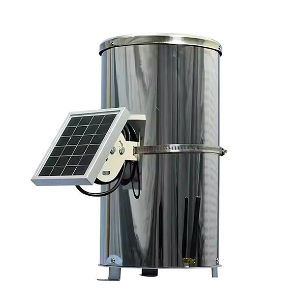
Water level meters (Limnimeters) | Measure surface water levels |
Flow meters | Measure flow in rivers and reservoirs |
Rain gauges | Measure rainfall levels |
Multi-parameter water quality sensors | Monitor pH, dissolved oxygen, heavy metals |
IoT radar sensors | Track rising water levels without contact |
Maintenance-free rain gauges | Provide continuous rainfall data |
BGT’s water level monitor devices, like IoT radar sensors and maintenance-free rain gauges, help you collect data during storms or floods. These sensors work well in hard weather and do not need much care. You can use them to watch places that are hard to reach. Multi-parameter water quality sensors help you check for pollution during floods. This makes your flood response better.
Tip: A network of water level monitor sensors helps you see all water changes.
Data Transmission
You want your water level monitor system to send data fast and safely. Most modern systems use wireless networks, satellite links, or cellular connections for remote monitoring. This lets you get updates from sensors far away in real time. Some systems use smart algorithms, like the Extended Kalman Filter, to make data more correct. These methods help you see changes in water levels and flow before they get bad.
Remote monitoring lets you watch water levels, rainfall, and water quality from anywhere.
Data goes from sensors to your analysis platform right away, so you can act quickly.
Analysis Platforms
When your water level monitor devices send data, analysis platforms help you understand it. These platforms use visualization tools to show patterns and trends. You can see when water levels go up or when rainfall gets heavy. Alerts warn you about floods, so you can act fast. Advanced platforms use AI and cloud computing to keep your data up to date and easy to find. This helps you make smart choices and keep your community safe.
Note: Good analysis platforms help with reports and let you share information with others.
Flood Prevention with Real-Time Data
Early Warning Systems
You must act quickly if a flood is coming. Real-time hydrological monitoring helps you spot danger early. Precipitation Sensors show how much rain is falling right now. Level Sensors watch water rising in rivers and lakes. Velocity & Flow Sensors tell you how fast water moves. Water Quality Sensors check for pollution during floods. These tools work together to help you see what is happening.
Early warning systems save lives and protect homes. When you get alerts from real-time data, you have more time to stop floods. You can tell people to leave or move to safe places. Studies say early warning is one of the best ways to control floods. For every 1 Euro spent on early warning in Europe, up to 400 Euros in damage can be saved. In Bangladesh, early warning systems have helped lower deaths during big storms by giving people time to get ready.
Early warning lets you act before things get worse. You can help before the flood grows.
BGT’s technology helps early warning by using stations that watch rain and water levels. These stations send alerts when they see something strange. Smart alerting lets you set different warning levels, so you always know when to act.
Decision-Making Support
You need good facts to make smart choices in a flood. Real-time data from hydrological monitoring shows you what is happening now. This data helps you manage floods by showing where water is rising and which places are at risk.
Decision Support Tool | How It Helps You Take Action |
Real-time Flood Monitoring | Gives you current, local data to guide flood control measures |
Community Sensor Networks | Helps you plan for future floods by learning from past events |
Predictive Flood Models | Uses sensor data to improve flood forecasts and warnings |
Real-time Flood Alerts | Sends alerts to you and emergency teams for quick response |
Storm Recovery Assistance | Helps you track damage and plan repairs after a flood |
When you use BGT’s sensors, you get correct data for every area. The system can send alerts to your phone or computer. You can see which places need help first. Real-time data also helps you plan for the future. You can use it to build better flood controls and protect important places like hospitals and schools.
Note: Real-time hydrological monitoring gives you the facts you need to make quick, smart choices.
Community Protection
You keep your community safe by acting early and sharing news. Real-time flood tools help you protect everyone. Precipitation Sensors and Level Sensors help you spot problems before they get big. Velocity & Flow Sensors and Water Quality Sensors help you see how bad a flood is.
A good flood plan uses both technology and people. You can use real-time alerts to warn families and schools. Meetings and trusted sources help everyone know what to do. Two-way messages let you answer questions and give updates.
Strategy | Benefit for Your Community |
Personalized Communication | Builds trust and helps people take action |
Real-time, Two-way Alerts | Keeps everyone informed and ready to respond |
Credible Message Sources | Increases trust in flood warnings |
Extra Information Support | Makes instructions clear and easy to follow |
BGT’s real-time monitoring covers big areas and protects important places. The system checks water near key buildings and in risky flood zones. You can use this data to focus your flood work where it matters most. In Kyushu, real-time data has helped leaders find risky areas and use resources well. This way, there is better flood prevention and less damage.
Using real-time hydrological monitoring gives your community the best chance to stay safe during floods.
Real-World Benefits
Reduced Flood Damage
Real-time hydrological monitoring helps lower flood damage. Precipitation Sensors and Level Sensors warn you early about rising water. This gives you time to move people and protect things before floods get worse. With good data, you can plan evacuations and send help where it is needed most. Emergency teams can act quickly, so fewer homes and roads get hurt. Over time, communities using these systems lose less and recover faster after storms.
Early alerts from sensors help save lives and cut costs during disasters.
Faster Response
You can act faster in emergencies with up-to-date information. Velocity & Flow Sensors and Water Quality Sensors send real-time data to your team. This helps you spot problems, like fast water changes or pollution, right away. Advanced models, like the Bayesian convolutional neural network, help you find droughts and floods sooner than before. You can act up to three months earlier than with old ways. This extra time lets you get ready, warn people, and fix problems before they grow.
Real-time data helps you make quick choices.
You can send alerts to emergency crews and the public.
Resource managers know where to send help first.
Broader Applications
Hydrological monitoring does more than stop floods. You can use these systems for many jobs:
Application Type | Description |
Weather Data Integration | Makes forecasts better and helps you understand water events. |
Water Quality Monitoring | Watches the health of rivers and lakes in real time. |
Precipitation Sensors and Water Quality Sensors help keep city water clean by stopping pollution. You can change pumps and drains to keep dirty water out of rivers. Over time, you build a record of water trends, which helps you manage supplies and protect nature. These systems also help citizen science and teach people about water safety.
With BGT’s solutions, you get tools to manage water, stop pollution, and keep your community safe every day.
Real-time hydrological monitoring helps you get ready for floods. You can also act fast when floods happen. You use special tools like Precipitation Sensors and Level Sensors. Velocity & Flow Sensors and Water Quality Sensors are important too. Experts say these things matter most:
Real-time systems help you respond to disasters faster. They also help make better city rules.
Advanced tools save money and let you watch many places at once.
When people in the community help, monitoring works better. Using different ways keeps it strong.
Pick modern hydrological monitoring to keep your community safe. It also helps protect the environment.