Flood risks can escalate quickly when heavy rainfall causes rivers and reservoirs to rise. Without timely information, communities may have little time to prepare.
A flood early warning system helps identify developing threats by combining environmental sensors, real-time data transmission, and forecasting technologies. Understanding how these components work together is essential for improving flood preparedness and emergency response.
Key Components of a Flood Early Warning System
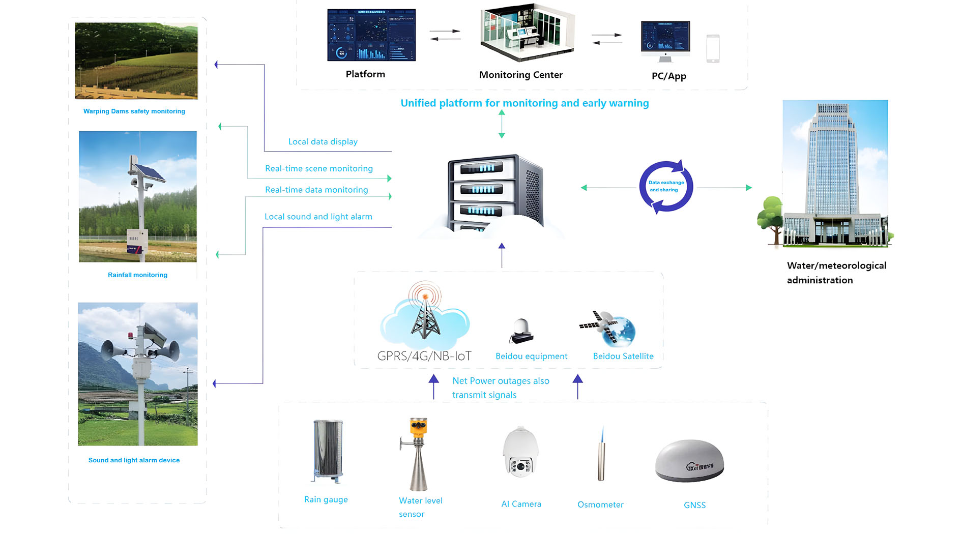
Flood early warning systems combine monitoring equipment, data processing, and communication technologies to detect potential flooding and issue timely alerts.
Flood Warning Sensors: Types and Functions
Flood warning sensors collect environmental data to identify changes that may indicate rising flood risks.
Common sensor types include:
Water Level Sensors and Gauges: Measure water levels in rivers, lakes, and reservoirs.
Rainfall Sensors: Record precipitation amounts and intensity.
River Flow and Velocity Sensors: Monitor water movement and detect sudden increases in flow.
Remote Sensing Technologies: Use satellites or drones to observe soil moisture and flood extent.
Together, these technologies provide essential information for flood forecasting and risk assessment.
Data Collection and Transmission Technologies
Once sensors collect data, the information must reach monitoring centers quickly and reliably.
Wireless networks, including cellular, radio, and satellite connections, transmit measurements from remote monitoring stations. Internet of Things (IoT) devices support continuous data sharing between connected sensors.
Data loggers can also store measurements locally during communication failures and upload them when connections are restored.
Reliable transmission helps ensure that flood warnings are issued without unnecessary delays.
Processing Centers and Decision-Making Units
Processing centers analyze incoming sensor measurements alongside weather forecasts and historical flood records.
Their main functions include:
Integrating hydrological and meteorological data.
Using forecasting models to predict potential flooding.
Evaluating flood severity and determining warning levels.
Government agencies, meteorological departments, and emergency management teams may use these results to coordinate appropriate responses.
Communication Channels for Alert Dissemination
An effective flood warning system must deliver information to people at risk through accessible communication channels.
Common methods include SMS notifications, mobile applications, public sirens, radio broadcasts, television announcements, and social media.
Using multiple channels increases the likelihood that residents and emergency responders receive important warnings in time.
Tip: Combine different communication channels to improve warning coverage and support faster community responses.

How a Flood Monitoring System Works
Real-time Data Acquisition from Sensors
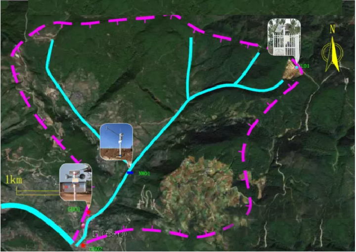
Flood monitoring begins with sensors installed near rivers, reservoirs, and flood-prone locations.
These devices continuously measure water levels, rainfall intensity, river flow, and velocity. Measurements are transmitted through wireless networks or IoT systems to monitoring centers.
Continuous data collection helps identify sudden environmental changes that may indicate developing flood conditions.
Hydrological and Meteorological Data Integration
Sensor measurements are combined with weather forecasts, temperature, humidity, and other meteorological information.
Hydrological data, including soil moisture, river basin characteristics, and historical flood records, provides additional context.
Integrating these datasets helps monitoring systems assess how rainfall and existing water conditions may influence flood development.
Data Analysis and Flood Forecasting Models
Forecasting models analyze collected information to estimate potential flooding.
Hydrological models simulate water movement through catchment areas, while meteorological models assess rainfall patterns.
Some systems also use machine learning to identify relationships in historical and real-time data.
These methods help estimate possible flood timing, severity, and affected areas, supporting emergency planning and risk assessment.
Triggering Alerts Based on Threshold Levels
Flood monitoring systems use predefined thresholds to determine when warnings should be issued.
The process typically follows these steps:
Monitor Conditions: Collect water level, rainfall, and river flow measurements.
Compare Thresholds: Evaluate sensor data and forecasts against established warning levels.
Trigger Alerts: Issue notifications when flood risk exceeds specified limits.
Support Response: Provide information for emergency preparation or evacuation.
Warning levels may range from flood watches to emergency evacuation notices, depending on the severity of the situation.

Types of Flood Warning Sensors Used in Monitoring Systems
Different flood warning sensors measure specific environmental conditions. Selecting suitable equipment helps monitoring systems collect reliable information across different locations.
Water Level Sensors and Gauges
Water level sensors measure changes in rivers, lakes, reservoirs, and other flood-prone areas.
Several technologies are commonly used:
Ultrasonic Sensors: Measure the distance to the water surface using reflected sound waves.
Pressure Sensors: Calculate water levels from pressure measurements.
Float Gauges: Track water level changes through mechanical floating devices.
These sensors help detect rising water levels and provide important information for flood warnings.
Rainfall Measurement Sensors
Rain gauges measure precipitation amounts and intensity, helping monitoring systems assess potential flood conditions.
Sensor Type | Measurement Method |
Tipping Bucket Rain Gauge | Measures rainfall by counting bucket movements as collected water reaches a specified volume |
Weighing Rain Gauge | Measures accumulated rainfall through changes in weight |
Optical Rain Sensor | Detects raindrops using light-based measurement |
Rainfall information helps forecasting systems estimate how precipitation may affect surrounding rivers and drainage networks.
River Flow and Velocity Sensors
River flow sensors measure water movement to identify changes that may increase flood risks.
Acoustic Doppler sensors use sound waves to measure water velocity. Electromagnetic sensors detect electrical signals generated by moving water, while current meters use mechanical movement to measure flow speed.
These measurements are particularly useful for monitoring sudden increases in river discharge or changes caused by dam releases.
Remote Sensing Technologies and Satellite Data
Remote sensing technologies provide environmental information across larger geographic areas.
Satellite imagery helps identify rainfall patterns, soil moisture, and flooded regions. Radar systems monitor precipitation and surface conditions, while drones capture detailed images of specific locations.
These technologies complement ground-based sensors, particularly in remote or difficult-to-access areas.
Applications of Flood Early Warning Systems
Flood early warning systems support disaster preparedness across cities, rural communities, infrastructure projects, and public safety programs.
Urban Flood Management and Emergency Response
Urban flood monitoring systems help authorities detect rising water levels in rivers and drainage networks.
Real-time alerts allow emergency teams to prepare evacuation measures, redirect traffic, and respond to affected areas.
During heavy rainfall, monitoring data can also help city officials determine when to activate drainage pumps or flood barriers.
Agricultural and Rural Area Flood Protection
Flood warnings provide farmers and rural communities with valuable preparation time.
Early notifications allow residents to:
Move livestock to safer locations.
Protect agricultural equipment.
Harvest crops early when conditions permit.
Prepare for evacuation if flooding becomes likely.
Rainfall and river flow monitoring are particularly important for low-lying agricultural areas exposed to sudden flooding.
Infrastructure Planning and Risk Assessment
Engineers and planners use historical flood records and real-time monitoring data to assess infrastructure risks.
This information supports decisions about roads, bridges, drainage systems, and flood protection structures.
Continuous monitoring also helps identify vulnerable infrastructure during extreme weather, supporting maintenance and emergency planning.
Community Awareness and Preparedness Programs
Flood early warning systems help communities understand local risks and prepare for emergencies.
Authorities can use warning messages to provide evacuation routes, shelter information, and safety instructions.
Schools, businesses, and community organizations may also incorporate these warnings into disaster preparedness plans.
Clear communication encourages timely responses and helps reduce confusion during flooding.
Tip: Adapt warning messages to the needs of different audiences, including residents, farmers, and emergency response teams.
Challenges in Implementing Flood Early Warning Systems
Flood monitoring systems face technical, communication, and operational challenges that can affect warning accuracy and reliability.
Technical Limitations of Sensors and Data Accuracy
Sensor performance may decline because of debris, environmental exposure, calibration errors, or equipment aging.
Water level sensors can produce inaccurate readings when obstructed, while rainfall sensors may not capture precipitation occurring outside their coverage areas.
These limitations can result in false alarms or missed warnings.
Regular inspection, cleaning, calibration, and data quality checks help maintain measurement accuracy.
Communication and Infrastructure Issues
Reliable data transmission is essential for continuous flood monitoring.
Remote areas may have limited cellular or internet coverage, while severe storms can damage communication equipment or interrupt power supplies.
Common challenges include:
Unstable wireless connections.
Power outages affecting monitoring stations.
Damaged communication towers or antennas.
Delayed transmission of critical sensor data.
Resilient communication infrastructure helps reduce these interruptions.
Integration with Local Emergency Services
Flood monitoring systems must coordinate effectively with local authorities and emergency responders.
Different communication platforms, unclear responsibilities, or delayed decisions can reduce the effectiveness of flood warnings.
Establishing data-sharing procedures and standard operating protocols helps agencies respond more efficiently.
Regular staff training also supports coordinated action during flood emergencies.
Maintaining and Upgrading Flood Monitoring Systems
Flood monitoring equipment requires ongoing maintenance to remain dependable.
Sensors need periodic cleaning, calibration, and replacement. Software and forecasting models must also be updated as new information becomes available.
Limited budgets or technical expertise may delay these activities, increasing the risk of unreliable system performance.

Future Trends in Flood Early Warning and Monitoring Systems
Advancements in Sensor Technology and IoT Integration
Flood monitoring sensors continue to improve in accuracy, durability, and energy efficiency.
Newer devices can detect changes in water levels, rainfall, and river flow while consuming less power, making them suitable for remote installations.
IoT technology connects monitoring devices and enables continuous data exchange, reducing the need for manual collection.
These developments support more responsive flood warning systems.
Use of AI and Machine Learning for Better Forecasting
Artificial intelligence (AI) and machine learning (ML) are increasingly used to analyze flood monitoring data.
Their applications include:
Identifying patterns in historical flood events.
Analyzing sensor measurements and weather information.
Updating forecasts as new data becomes available.
Supporting earlier identification of potential flood risks.
These technologies can improve forecasting capabilities and help authorities make more informed emergency decisions.
Enhanced Community Engagement Through Mobile Alerts
Mobile applications and SMS services make flood warnings more accessible to residents.
Notifications can provide information about rising water levels, evacuation routes, emergency shelters, and safety precautions.
Some applications also allow residents to report local flooding, blocked drainage systems, or other hazardous conditions.
This two-way communication helps communities stay informed and supports faster emergency responses.
Global Collaboration for Flood Risk Reduction
Flood risks often extend beyond national borders, making international cooperation important.
Countries and organizations share monitoring data, forecasting technologies, and disaster management experience to strengthen early warning capabilities.
Collaborative projects can also support the deployment of monitoring equipment in vulnerable regions with limited resources.
Sharing research and technical knowledge helps improve flood preparedness and monitoring systems worldwide.
Conclusion
An effective flood early warning system does more than measure rising water levels. It connects rainfall monitoring, river flow measurements, data analysis, and public alerts into a coordinated process that supports timely decisions.
However, reliable warnings depend on the entire monitoring network. Accurate sensors are essential, but communication failures, outdated forecasting models, or poorly coordinated emergency procedures can still delay responses. Regular calibration, dependable data transmission, and clear warning thresholds are therefore just as important as the monitoring equipment itself.
As IoT connectivity and AI-assisted forecasting continue to develop, flood monitoring systems can provide more detailed information for risk assessment and emergency planning. BGT Hydromet offers hydrometeorological monitoring solutions that support environmental data collection and flood risk monitoring. Combining suitable equipment with effective warning procedures helps authorities strengthen preparedness and reduce the potential impact of flooding.
FAQ
Q: What is a flood early warning system and how does it work?
A: A flood early warning system uses flood warning sensors to monitor water levels, rainfall, and river flow. Data is transmitted to processing centers for analysis, forecasting, and alert generation, helping communities prepare for potential flooding.
Q: Why are flood monitoring systems important?
A: Flood monitoring systems provide real-time environmental data to identify potential flooding. Early warnings help protect lives, reduce damage, and support emergency responses.
Q: What types of flood warning sensors are commonly used?
A: Common sensors include water level sensors, rainfall sensors, river flow sensors, and remote sensing technologies. Each provides different information for flood monitoring and forecasting.
Q: How much does implementing a flood early warning system cost?
A: Costs depend on sensor types, communication infrastructure, and overall system complexity. Reliable equipment and data transmission are important considerations when planning a monitoring system.
Q: How can I troubleshoot issues with flood warning sensors?
A: Regularly inspect and calibrate sensors, check communication connections, and maintain monitoring equipment. These measures help identify malfunctions and improve data accuracy.