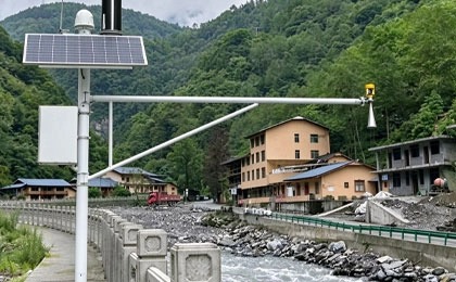
A river can rise rapidly after heavy rainfall, but a higher water level does not always mean a proportional increase in the volume of water moving downstream. Channel shape, flow resistance, and local hydraulic conditions all influence how a river responds.
This distinction matters when planning a monitoring station. A flood warning project may primarily need reliable water level measurements, while a water allocation project often requires discharge data. Some applications need both.
Choosing between water level and flow monitoring therefore begins with understanding what the collected data must explain. The right approach depends on the monitoring objective, river conditions, available infrastructure, and the level of measurement detail required.
Water Level Monitoring vs Flow Monitoring: Key Differences
What Does a River Water Level Sensor Measure?
A river water level sensor measures the height of the water surface relative to a defined reference level.
Measurements show whether the river is rising, falling, or remaining relatively stable. This information is useful for identifying changing flood conditions, monitoring reservoir levels, and assessing water levels near bridges or other infrastructure.
Water level sensors commonly use radar, ultrasonic, or pressure-based measurement technologies.
For continuous observation, readings are collected at scheduled intervals and recorded by a data logger. Where communication infrastructure is available, measurements can also be transmitted to a remote monitoring platform.
Water level data is particularly valuable when the main concern is how high the water has reached.
However, water level alone does not directly indicate the total volume of water moving through a river channel.
What Does River Flow Monitoring Measure?
River flow monitoring focuses on water movement. Depending on the equipment and measurement method, it may provide water velocity, discharge, or both.
Velocity describes how quickly water moves through a channel. Discharge represents the volume of water passing a particular cross-section over a given period, commonly expressed in cubic meters per second.
A water velocity sensor does not necessarily measure total discharge directly. Discharge estimation may also require channel geometry, water depth, or a validated relationship between water level and flow.
Common measurement approaches include acoustic Doppler instruments, ultrasonic velocity sensors, electromagnetic velocity sensors, and mechanical current meters.
Flow monitoring is particularly useful when a project needs to understand how much water is moving through a river.
Comparison of Water Level and Flow Monitoring
Comparison | Water Level Monitoring | Flow Monitoring |
Primary measurement | Water surface elevation | Water velocity or discharge |
Main question | How high is the water? | How much water is moving? |
Common equipment | Radar, ultrasonic, and pressure level sensors | Velocity sensors, ADCPs, and discharge measurement systems |
Typical applications | Flood thresholds, reservoir levels, infrastructure monitoring | Water allocation, hydrological analysis, discharge assessment |
Installation considerations | Reference elevation and sensor positioning | Flow distribution, channel geometry, and sensor positioning |
Data processing | Level trends and threshold analysis | Velocity processing and discharge estimation |
Maintenance requirements | Depend on sensor technology and exposure | Depend on technology, sediment, and measurement arrangement |
Neither method is inherently better. Each provides different information, and the value of that information depends on the project.

When Should a River Monitoring Project Prioritize Water Level or Flow?
Water Level Monitoring for Flood Warning and Infrastructure Protection
Water level monitoring is often the practical starting point for projects concerned with rising water.
At a bridge, for instance, the immediate operational question may be whether the river is approaching a predefined warning elevation. A water level sensor can provide the measurement needed for that threshold-based alert.
Similar requirements occur at culverts, flood-prone riverbanks, reservoirs, and other locations where water surface elevation affects operational decisions.
Water level monitoring is commonly used for:
· Detecting rising river levels during rainfall events.
· Supporting threshold-based flood alerts.
· Monitoring reservoir and storage levels.
· Observing water levels near hydraulic structures.
· Recording seasonal changes in river stage.
For such applications, a dedicated river water level monitoring system may meet the primary measurement requirement without continuous velocity measurement.
This does not mean water level data alone can provide a complete flood forecast. Forecasting may also require rainfall observations, upstream conditions, hydrological models, and other information.
Flow Monitoring for Water Allocation and Discharge Assessment
When the objective involves water quantity rather than water height, discharge becomes more important.
Consider an irrigation project drawing water from a river. Knowing the river level provides useful context, but it does not necessarily establish how much water is available or moving past the intake.
Discharge measurements offer a more relevant basis for evaluating water movement.
Flow monitoring is commonly required for:
· River discharge assessment.
· Water resource allocation.
· Irrigation and abstraction planning.
· Environmental flow studies.
· Hydrological model calibration.
· Evaluating flow conditions near hydraulic infrastructure.
The measurement method should match the channel characteristics and required accuracy.
For projects involving continuous velocity observation or discharge estimation, a river flow monitoring system can form part of the measurement arrangement.
When Are Both Measurements Necessary?
Some projects cannot be adequately described by a single parameter.
A river monitoring station may need water level data to identify changes in stage and velocity measurements to understand how those changes affect water movement.
Combining the two can be particularly useful where the relationship between water level and discharge is variable or difficult to establish.
For example, a radar flow meter can combine water level and surface velocity measurements to support river discharge estimation.
Project Scenario | Water Level | Flow or Discharge | Selection Consideration |
Flood threshold monitoring | Primary | Optional | Level alerts may meet the immediate objective |
Water allocation | Useful | Primary | Water quantity is the main concern |
Reservoir level observation | Primary | Depends on scope | Inflow and outflow studies may require discharge |
Environmental flow assessment | Useful | Primary | Discharge supports flow condition analysis |
River hydraulic studies | Required in many cases | Required in many cases | Combined measurements support broader analysis |
Bridge water level alerts | Primary | Optional | Additional flow data depends on engineering requirements |
A combined system is not automatically necessary for every river station.
The additional measurements should address a defined information gap rather than simply increase the amount of collected data.
Choosing Suitable Water Level Sensors and Flow Measurement Equipment
Comparing River Water Level Sensor Technologies
Radar, ultrasonic, and pressure sensors are commonly considered for river water level measurement.
Radar water level sensors measure the distance to the water surface using electromagnetic signals. Their non-contact design can reduce exposure to sediment and floating debris.
Ultrasonic water level sensors use reflected sound waves to determine the distance between the instrument and water surface. They can be suitable for bridge-mounted and other above-water installations.
Submersible water pressure level sensors estimate water depth from hydrostatic pressure. They require contact with water and appropriate consideration of pressure compensation, sediment, and maintenance access.
Sensor Type | Installation | Main Consideration |
Radar level sensor | Above the water | Measurement range, mounting geometry, and signal conditions |
Ultrasonic level sensor | Above the water | Temperature effects, condensation, and surface conditions |
Pressure transducer | Submerged | Sediment, pressure compensation, and maintenance |
Float-based sensor | In a suitable measuring arrangement | Mechanical movement and protection from debris |
For a remote river with substantial floating debris, non-contact measurement may reduce certain maintenance risks.
For a protected installation where submerged measurement is practical, a pressure sensor may be an appropriate alternative.
Comparing River Flow Measurement Technologies
River flow measurement requires a different set of considerations.
A radar velocity meter measures surface water movement without direct contact with the river. An acoustic Doppler current profiler can provide more detailed velocity information across portions of the water column.
Electromagnetic sensors measure local water velocity using electromagnetic induction, while mechanical current meters are commonly used for field measurements.
Technology | Measurement Capability | Important Limitation |
Surface velocity sensor | Measures surface water movement | Requires a suitable method to estimate mean velocity and discharge |
Acoustic Doppler current profiler | Measures velocity profiles | Performance depends on acoustic and flow conditions |
Electromagnetic velocity sensor | Measures local water velocity | Requires suitable water conductivity and installation |
Mechanical current meter | Measures velocity at selected points | Moving components require maintenance |
For discharge measurement, the selected technology must be considered together with the river cross-section and measurement procedure.
A sensor capable of measuring velocity should not be assumed to provide an accurate total discharge value without the necessary supporting information.
Can Water Level Data Be Used to Estimate River Discharge?
In some river sections, discharge can be estimated from water level measurements using an established stage-discharge relationship, also called a rating curve.
Hydrologists develop this relationship by collecting direct discharge measurements at different water levels.
Once the relationship has been established and validated, continuous water level observations can support ongoing discharge estimation.
However, rating curves are not equally reliable under all conditions.
Sediment deposition, channel erosion, vegetation changes, backwater effects, and changing hydraulic conditions can alter the relationship between water level and discharge.
Periodic discharge measurements and rating curve verification remain important.
For rivers with unstable channel conditions, additional velocity measurements may be necessary to improve discharge estimation.
Planning a River Hydrological Monitoring System
Define the Measurement Requirements Before Selecting Equipment
Equipment selection should follow the project requirements rather than the other way around.
A useful starting point is to identify the decisions that will be made from the monitoring data.
For instance, an automated flood alert may require frequent water level readings and reliable notification delivery. A hydrological research project may place greater emphasis on measurement accuracy, long-term consistency, and discharge estimation.
Before specifying sensors, project engineers should establish:
· The primary monitoring objective.
· Required measurement parameters.
· Expected minimum and maximum water levels.
· River width, depth, and flow characteristics.
· Required accuracy and sampling frequency.
· Available power and communication infrastructure.
· Maintenance accessibility.
· Data storage and integration requirements.
These details help determine whether the project needs a water level sensor, a velocity measurement system, or a combined monitoring station.
Consider Installation Conditions and Long-Term Operation
River monitoring equipment must operate under changing environmental conditions.
Heavy rainfall, sediment, floating debris, high humidity, and seasonal water level variations can affect both measurement quality and equipment reliability.
Non-contact sensors require stable mounting and a clear measurement path. Submerged instruments need suitable protection and positioning.
Flow measurement equipment may also require information about channel geometry and representative measurement locations.
For remote stations, power supply and communication are additional concerns.
Solar panels with rechargeable batteries can support unattended operation when appropriately sized. Cellular, satellite, or radio communication may be used depending on coverage and project requirements.
Local data logging is valuable when temporary communication interruptions are expected.
The most appropriate system is one that can maintain the required measurement quality under the actual operating conditions, not merely one with the largest number of functions.
Evaluate System Integration and Total Operating Cost
A river monitoring station often contains several connected components.
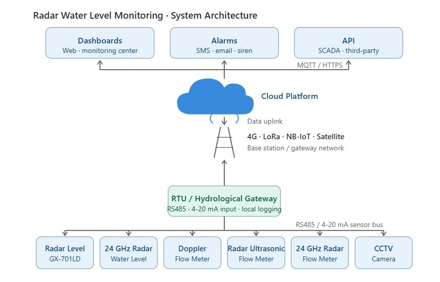
Sensors collect measurements, data loggers record readings, communication equipment transmits information, and software platforms organize the results.
When different measurement technologies are combined, their interfaces and data formats must be compatible.
A complete procurement assessment should consider more than equipment purchase price.
Cost or Technical Factor | What to Evaluate |
Sensor equipment | Measurement capability and required accuracy |
Mounting infrastructure | Bridge brackets, support structures, and protection |
Power supply | Grid connection, solar system, or battery capacity |
Communication | Coverage, data requirements, and service costs |
Software integration | Data compatibility and platform requirements |
Calibration | Reference measurements and verification procedures |
Maintenance | Site access, cleaning, repairs, and replacement parts |
A lower initial purchase price may not result in lower long-term costs if the installation requires frequent field visits or extensive maintenance.

Using Water Level and Flow Data Together
Interpreting Changes in River Conditions
Water level and discharge do not always change at the same rate.
A rise in water level may accompany increased discharge, but the relationship depends on channel geometry, downstream conditions, and flow resistance.
In some river sections, downstream backwater can raise the water surface without a corresponding proportional increase in discharge.
Comparing level and flow records can help identify these differences.
For long-term monitoring, measurements should use consistent timestamps, reference levels, and quality control procedures.
Supporting Flood Monitoring and Water Management
Combined hydrological data can support several operational activities.
Water level measurements provide information about changing river stage. Velocity and discharge observations add information about water movement.
Together, these measurements may help engineers assess hydraulic conditions, evaluate water availability, and improve the inputs used in hydrological models.
Monitoring platforms can display historical trends and generate alerts when predefined conditions are reached.
However, automated alerts must be distinguished from predictive flood models. The reliability of a forecast depends on the broader dataset, model configuration, and local river conditions.
Conclusion
The choice between water level and flow monitoring is ultimately a question of what the river monitoring project needs to know.
For a station designed to detect rising water near a bridge, water level measurement may be sufficient. For a project evaluating river discharge or water allocation, velocity and flow measurements become more important. Where both river stage and water movement influence decisions, a combined approach can provide a stronger measurement basis.
This project-specific approach is also reflected in the hydrological and meteorological monitoring equipment offered by BGT Hydromet. Its river hydrological monitoring solutions address the broader need to collect and manage river measurements, allowing system requirements to be considered in relation to local conditions and monitoring objectives.
FAQ
What is the main difference between water level and flow monitoring?
Water level monitoring measures river surface elevation, while flow monitoring measures water movement through velocity or discharge observations.
Can a water level sensor measure river discharge?
Not directly. Discharge may be estimated using a validated stage-discharge relationship supported by field measurements.
When does a river monitoring project need both measurements?
Both may be useful when river stage and discharge are needed for hydraulic studies, water management, or detailed monitoring of changing flow conditions.
Which water level sensor is suitable for a remote river?
Radar and ultrasonic sensors are common non-contact options. Selection depends on the measurement range, environment, power supply, and installation conditions.
What should be considered when selecting river flow monitoring equipment?
Important factors include channel geometry, flow variability, measurement accuracy, sensor technology, installation access, and long-term maintenance requirements.