In recent years, the world has witnessed an alarming increase in forest fires, from the blazing landscapes of Australia to the fiery coasts of the Mediterranean. The confrontation between human efforts and natural forces is intensifying. In Sichuan's Liangshan alone, challenges such as lightning-induced fires and hidden smoldering spots rekindled by strong winds have made firefighting operations exceptionally difficult. While traditional methods—relying on human patrols and helicopter water drops—remain indispensable, they are plagued by limitations such as restricted visibility, delayed response times, and high risks for pilots.
Here we will talk about: drones equipped with specialized visibility sensors and 3D wind speed direction sensors are becoming game-changers in forest fire prevention. They not only bridge the monitoring gap between human eyes and satellites but also bring precision and predictability to firefighting efforts through data-driven decision-making.
1. Why Forest Fires Must Be Intervened
The idea of letting forest fires burn may seem like "respecting nature," but it carries significant hidden dangers:
Ecological Disaster: Once a forest ecosystem is destroyed, it can lead to secondary disasters like soil erosion and mudslides, which may take centuries to recover from. Regional microclimates can also be permanently altered.
Threat to Human Lives: In China, forested areas often intertwine with residential zones and farmland. Fires can easily spread to human settlements, as evidenced by the 1987 Great Khingan Mountains fire that engulfed Mohe City.
Global Challenges: Climate change has led to increased high-temperature droughts and more frequent lightning fires (e.g., Canada’s 2023 burned area reached 120,000 km²). Human activities (such as farming and ritual burning) account for over 90% of fire causes.
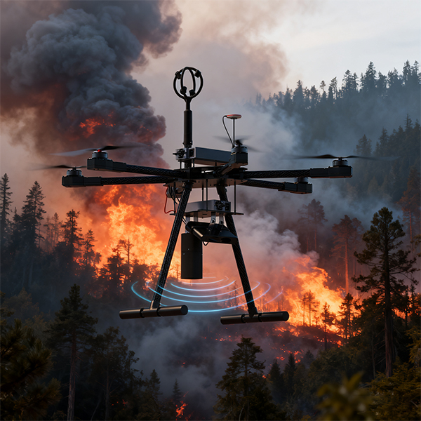
2. Drones + Sensors: The "Data-Transparent Eye" for Firefields
Drones equipped with backscatter visibility sensors (20-4000m range) and 3D wind speed direction sensors form the core sensory system for firefield monitoring:
2.1 Early Warning: Detecting Hidden Fire Sources
Visibility Sensor: Monitors smoke density in real-time, generating evacuation recommendations and fire location data integrated with GIS systems.
Wind Speed Direction Sensor: Precisely captures airflow changes, predicting the path and speed of fire spread.
Case Study: In Hefeng County, Hubei Province, an AI-powered drone system achieved sub-minute response times, reducing smoke point verification costs by over 99%.
2.2 During Firefighting: Guiding Precision Operations
Guiding Ground Teams: Drones generate high-precision firefield maps, directing firefighters away from hazardous areas (e.g., cliffs and ravines).
Coordinating Helicopter Operations: Providing real-time wind data to optimize water drop trajectories, avoiding ineffective high-altitude releases (helicopters require low-altitude operations for effectiveness).
Case Study: The Tahe Forestry Bureau in the Great Khingan Mountains used drones equipped with high-temperature sensors to inspect 6,321 lightning strike points, forming a closed loop of "warning-patrol-response."
2.3 Post-Fire Phase: Assessment and Restoration
Rapidly scan burned areas to assess tree loss.
Monitor soil stability to prevent secondary disasters.
3. The "Iron Triangle" Collaboration: Humans, Helicopters, and Drones
Role
Traditional Limitations
Drone-Enabled Strategies
Human Teams
Limited visibility, night ops
Real-time thermal imaging for firebreak guidance
Helicopters
High risk, visible-light reliance
Wind data for optimized water drop paths
Command Center
Data delays, experience-based decisions
Multi-source data fusion for fire spread modeling
Practical Applications:
Dehua County, Fujian, deployed 36 drones to cover 3.34 million acres of forestland, identifying and stopping 26 cases of illegal fire use in 2024.
The Dailing Forestry Bureau in Heilongjiang used drones for patrols, improving efficiency 30-fold and replacing a 20-person team for close-range reconnaissance.
4. Technological Frontiers: How Your Sensors Empower Fire Prevention Networks
If your equipment features the following:
Visibility Sensor: Ultra-lightweight (59g), ultra-low power consumption (0.9W), operating temperatures from -20°C to 50°C.
Wind Sensor: Real-time 3D airflow mapping.
Focus on these application directions:
Fire Spread Modeling:
Use wind speed and direction data to simulate fire movement, providing guidance for setting up firebreaks.
Dynamic Evacuation Route Optimization:
Integrate visibility data with GIS to generate real-time safe evacuation paths, avoiding smoke-filled areas.
Drone Swarm Networking:
Deploy multiple drones for broader coverage, creating an integrated "air-space-ground" monitoring system (e.g., Hubei’s Hefeng fully automated inspection system).
5. The Critical Role of Drone Weather Sensors
The integration of Drone Weather Sensors—specifically UAV Ultrasonic Anemometers and Wind Speed Direction Sensors—has revolutionized how we monitor and respond to forest fires. These sensors provide real-time meteorological data directly from the firefront, enabling responders to make informed decisions under extreme conditions.
UAV Ultrasonic Anemometer: This sensor uses ultrasonic waves to measure wind speed and direction without moving parts, making it highly durable and accurate even in smoky, high-turbulence environments. Its lightweight design (typically under 100g) ensures minimal impact on drone flight performance.
Wind Speed Direction Sensor: Essential for tracking micro-level wind patterns that dictate fire behavior, this sensor helps predict sudden fire shifts caused by wind gusts or changing air currents.
Visibility Sensor: By detecting particulate matter in the air (e.g., smoke, dust), this sensor provides critical insights into air quality and safe flight conditions for both drones and manned aircraft.
Together, these sensors form a comprehensive Drone Weather Monitoring System that enhances situational awareness and reduces operational risks.
Conclusion: Protecting Lives Through Technology and Respect for Nature
Forest fire prevention is not about conquering nature but using technology to balance ecological integrity and human safety. Drones and sensors provide not just data but a new language for communicating with nature—a language that offers precious warning time, precise decision-making, and safe evacuations in the face of lightning, high winds, and droughts.
As a firefighting commander with 20 years of experience once said: "I survived 20 years not because of skill, but because of luck." Today, we are using technology to turn "luck" into "certainty."
The value of technology lies not in replacing human or natural forces but in finding a path to safeguard life through wisdom and reverence.
Related Products
content is empty!
Related Blogs
content is empty!
Meanwhile, we have software and hardware R&Ddepartmentand a team of experts to support customers' project planning and customized services


 h as restricted visibility, delayed response times, and high risks for pilots.


